Floating LiDAR Systems (FLS)
Floating LiDAR Systems are used worldwide in wind resource assessment (WRA) studies. MEASNET, the Carbon Trust, but also the IEA guidelines recommend that the LiDAR systems used be regularly validated/verified by an independent institute.
General
In wind resource assessments using a LiDAR MEASNET, Carbon Trust and IEA guidelines recommend to regularly perform LiDAR validations/verifications by a recognized institute. TNO Wind Energy is ISO 17025 accredited for power performance measurements, mechanical loads measurements, meteorological measurements and for performing remote sensing verification measurements according to IEC 61400-12-1. Since the end of 2020 TNO Wind Energy is also accredited for performing validation campaign of Floating LiDAR Systems. Furthermore, TNO Wind Energy is an IECRE approved test lab for power performance and mechanical loads. ECN is one of the founding fathers of MEASNET and is also as TNO active member of the MEASNET Expert Group ‘Remote Sensing Devices’ and ‘Power Performance’. Furthermore, TNO is member of the IEC 61400-50-4 working group. With its work, it has laid the foundation for the present day standards.
TNO is an independent research organization. We connect people and knowledge to create innovations that boost the sustainable competitive strength of industry and well-being of society. For this purpose, TNO is established by law as legal public entity. The TNO-law gives us a number of special tasks and frameworks and linking it to specific conditions under which we have to perform our work. So that we can continue to create independent and reliable solutions to the challenges that society presents us.
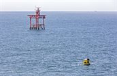
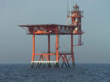
Lichteiland Goeree (LEG)
On a distance of about 30 km south-west from Hoek van Holland a platform called Lichteiland Goeree is situated. The coordinates of the platform are: 51°56′ NB, 3°40′ OL. The platform serves as a beacon for ships on the North sea and is also used for meteorological measurements by KNMI and Rijkswaterstaat (RWS).
Around the LEG platform TNO operates 20 locations for the verifications of Floating LiDAR Systems.
Accredited FLS measurement campaigns
TNO Wind Energy is ISO 17025 accredited for power performance measurements, mechanical loads measurements, meteorological measurements and for performing remote sensing verification measurements according to IEC 61400-12-1. Since the end of 2020 TNO Wind Energy is also accredited for performing validation campaign of Floating LiDAR Systems.
References
The following references are leading for the Floating LiDAR System activities of TNO. A new IEC guideline for Floating LiDAR Systems – IEC 61400-50-4 is released in May 2025.
- MEASNET, ‘Evaluation of Site-specific Wind Conditions’, version 3, September 2022
- IEA Wind Expert group study on recommended practices. 18 Floating LiDAR systems, first edition, September 2017
- Carbon Trust Offshore Wind Accelerator Roadmap for the Commercial Acceptance of Floating LiDAR Technology, version 2.0, October 2018