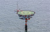
Europlatform
On a distance of about 50 km south-west from Hoek van Holland a platform called Europlatform is situated. The coordinates of the platform are: 51°60′ NB, 3°16′ OL. The platform serves as a beacon for ships on the North Sea and is also used for meteorological measurements and wave measurements by KNMI and Rijkswaterstaat (RWS).
Introduction
The Wind Energy department of TNO Energy Transition & Materials carries out a meteorological measurement program for the government (Ministry of Climate Policy and Green Growth) in the Dutch part of the North Sea. We provide developers and other interested parties with information about the meteorological conditions for future wind farms in the North Sea. We are currently carrying out measurements at five measuring locations (Lichteiland Goeree - LEG, Europlatform - EPL, K13A, L2-FA-1 and F2-A-Hanze). In addition, historical data sets are available from a number of measurement locations, such as Meteorological Measuring Mast IJmuiden (MM-IJ) and Meteorological Measuring Mast OWEZ (MM-OWEZ).
Measurement campaign
Since beginning of May, 2016 TNO is performing meteorological measurements on Europlatform (EPL) with a ZX LiDAR. All the data is stored in a database and is made publicly available on this website. A LIDAR system is mounted on the platform.
The LiDAR measures wind speeds and directions at 63, 91, 116, 141, 166, 191, 216, 241, 266 and 291 meter. The LiDAR signals are general signals and for each height.
| Acronym |
Signal name |
Units |
|---|---|---|
| EPL_batvoltage | Battery Voltage | V |
| EPL_tempcpu | CPU-temperature inside the LiDAR | deg C |
| EPL_humpod | Relative Humidity inside the LiDAR | % |
| EPL_bearing | LiDAR bearing | Deg |
| EPL_tilt | LiDAR tilt angle | Deg |
| EPL_pair | Air Pressure at LiDAR position | hPa |
| WPL_wsmet | Wind speed measured by LiDAR meteo station | m/s |
| EPL_wdmet | Wind direction measured by LiDAR meteo station | Deg |
| EPL_HXXX_npts | Measuring points | |
| EPL_HXXX_missed | Missed points | |
| EPL_HXXX_npackets | Packets in fit | |
| EPL_HXXX_Wd | Wind direction | Deg |
| EPL_HXXX_Wshor_avg | Horizontal wind speed average | m/s |
| EPL_HXXX_Wshor_std | Horizontal wind speed standard deviation | m/s |
| EPL_HXXX_Wshor_min | Horizontal wind speed minimum | m/s |
| EPL_HXXX_Wshor_max | Horizontal wind speed maximum | m/s |
| EPL_HXXX_Wshor_avg | Vertical wind speed average | m/s |
| EPL_HXXX_cs | CS |
Installation and Maintenance – ZX 300M
To perform wind speed measurements, a ZX 300M has been installed that can measure up to a height of 300 meters above sea level. The laser beam is safe for the eyes according to IEC EN 60825-1, January 2008.
Since May 2016 the LiDAR performs measurements at the platform. The LiDAR is regularly maintained and replaced with a newly calibrated LiDAR.
Data validation
During measurements failures can occur. This is why the measured data is checked for errors to prevent ‘pollution’ of the database. This happens in two steps:
- The measurement computer checks for failures such as
- No connection with a sensor
- No connection with the measurement system
- A value of a signal exceeds a minimum or maximum value
- The measured data is daily checked manually for deviations
This data is filtered out and marked as ‘invalid’. When requesting the data from the database the ‘invalid’ data is not provided, so the user can be confident working with valid data.
Accreditation
Measurements on platforms Lichteiland Goeree - LEG, Europlatform - EPL, K13A, L2-FA-1 and F2-A-Hanze are performed by TNO under accreditation 'L324 meteorological measurement'.
Reporting
Instrumentation report
Validation- and/or Verification reports
- Verification of the Wind@Sea LiDAR system ZX563 at the EWTW test site near meteorological mast MM6. Period: 12 October 2023 to 5 December 2023
- Validation of the TNO ZX300 LiDAR system unit 308 at the TNO RSD Verification Facility Period July 2019 to September 2019
- Verification of ZephIR 300 unit 315 at ECN part of TNO LiDAR Calibration Facility, for offshore measurements at Euro Platform (EPL)
Windconditions
Data
To download the data from Europlatform (EPL), you will be redirected to the registration page, after registration, the data is accessible.