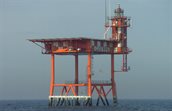
Lichteiland Goeree
On a distance of about 30 km south-west from Hoek van Holland a platform called Lichteiland Goeree is situated. The coordinates of the platform are: 51°56′ NB, 3°40′ OL. The platform serves as a beacon for ships on the North sea and is also used for meteorological measurements by KNMI and Rijkswaterstaat (RWS).
Introduction
The Wind Energy department of TNO Energy Transition & Materials carries out a meteorological measurement program for the government (Ministry of Climate Policy and Green Growth) in the Dutch part of the North Sea. We provide developers and other interested parties with information about the meteorological conditions for future wind farms in the North Sea. We are currently carrying out measurements at five measurement locations (Lichteiland Goeree - LEG, Europlatform - EPL, K13A, L2-FA-1 and F2-A-Hanze). In addition, historical data sets are available from a number of measurement locations, such as Meteorological Measuring Mast IJmuiden (MM-IJ) and Meteorological Measuring Mast OWEZ (MM-OWEZ).
Measurement campaign LEG
Since the end of 2014 TNO is performing meteorological measurements on Lichteiland Goeree (LEG) with a LiDAR. All the data is stored in a database and is made publicly available on this website. A LiDAR system is mounted on the platform.
The LiDAR measures wind speeds and directions at 62, 90, 115, 140, 165, 190, 215, 240, 265 and 290m. The LIDAR signals provided are general signals and measurement height specific signals.
|
Abbreviation |
Signal name |
Units |
|---|---|---|
|
LEG_Int_Temp |
Internal temperature |
°C |
|
LEG_Wiper_count |
Number of wiper activations |
- |
|
LEG_HXXX_CNR |
Mean carrier-to-noise ratio |
dB |
|
LEG_HXXX_CNR_min |
Minimum carrier-to-noise ratio |
dB |
|
LEG_HXXX_Data_Avail |
Data availability |
% |
|
LEG_HXXX_DSB |
Doppler spectral broadening |
Hz |
|
LEG_HXXX_Wd |
Mean wind direction |
° |
|
LEG_HXXX_Ws |
Mean wind speed |
m/s |
|
LEG_HXXX_Ws_max |
Maxiumum wind speed |
m/s |
|
LEG_HXXX_Ws_min |
Minimum wind speed |
m/s |
|
LEG_HXXX_WsDisp |
Standard deviation of the wind sped |
m/s |
|
LEG_HXXX_Z-Ws |
Vertical wind speed component |
m/s |
LiDAR installation and maintenance - Vaisala Windcube V2
To perform wind speed measurements, a Vaisala Windcube V2.1 has been installed that can measure up to a height of 300 meters above sea level. The laser beam is safe for the eyes according to IEC EN 60825-1, January 2008.
Since October 2014 the LiDAR performs measurements at the platform. The LiDAR is regularly maintained and replaced with a newly calibrated LiDAR.
Data validation
During measurements failures can occur. This is why the measured data is checked for errors to prevent ‘pollution’ of the database. This happens in two steps:
- The measurement computer checks for failures such as
- No connection with a sensor
- No connection with the measurement system
- A value of a signal exceeds a minimum or maximum value
- The measured data is daily checked manually for deviations
This data is filtered out and marked as ‘invalid’. When requesting the data from the database the ‘invalid’ data is not provided, so the user can be confident working with valid data.
Accreditation
Measurements on platforms Lichteiland Goeree - LEG, Europlatform - EPL, K13A, L2-FA-1 and F2-A-Hanze are performed by TNO under accreditation 'L324 meteorological measurement'.
Reporting
Instrumentation reports
Validation- and/or Verification reports
- Verification of the Vaisala WindCube v2.1 LiDAR system unit WLS866-0184 near MM6
- LiDAR system WLS866-0183 at the EWTW test site near meteorological mast MM6. Period: 12 October 2023 to 5 December 2023
- Verification of Vaisala WindCube v2 LiDAR system unit WLS7-127 at the TNO RSD Verification Facility Period: February 2020 to June 2020
- Verification of Vaisala WindCube V2 unit WLS7-258 at TNO LiDAR Calibration Facility, for offshore measurements at Lichteiland Goeree
- “Verification of Vaisala Windcube WLS7-577 at ECN part of TNO LiDAR Calibration Facility, for offshore measurements at Lichteiland Goeree”
Windconditions
General
Data
To download the data from Lichteiland Goeree (LEG), you will be redirected to the registration page, after registration, the data is accessible.