L2-FA-1 platform
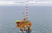
The L2-FA-1 offshore platform owned by NAM B.V. is located north of the Frisian Islands, 80 kilometers from the coast. The coordinates of the platform are: 53°58′ NB, 4°30′ OL. The platform serves as a production platform for natural gas.
Introduction
The Wind Energy department of TNO Energy Transition & Materials carries out a meteorological measurement program for the government (Ministry of Climate Policy and Green Growth) in the Dutch part of the North Sea. We provide developers and other interested parties with information about the meteorological conditions for future wind farms in the North Sea. We are currently carrying out measurements at four measuring locations (Europlatform – EPL, K13A, L2-FA-1 and Lichteiland Goeree – LEG). In addition, historical data sets are available from a number of measurement locations, such as Meteorological Measuring Mast IJmuiden (MM-IJ) and Meteorological Measuring Mast OWEZ (MM-OWEZ).
Measurement campaign
Since spring 2023 TNO is performing meteorological measurements on L2-FA-1 with a ZX LiDAR. All the data is stored in a database and is made publicly available on this website.
The LIDAR measures wind speeds and directions far above the mast, at 63, 91, 116, 141, 166, 191, 216, 241, 266, and 291 meter. The LIDAR signals provided are general signals and measurement height specific signals.
| Acronym | Signal name | Units |
|---|---|---|
| L2FA_batvoltage | Battery Voltage | V |
| L2FA_tempcpu | CPU temperature inside the LiDAR | deg C |
| L2FA_humpod | Relative Humidity inside the LiDAR | % |
| L2FA_bearing | LiDAR Bearing | Deg |
| L2FA_tilt | LiDAR tilt angle | Deg |
| L2FA_pair | Air Pressure at LiDAR position | hPa |
| L2FA_wsmet | Wind speed measured by LiDAR meteo station | m/s |
| L2FA_wdmet | Wind direction measured by LiDAR meteo station | Deg |
| L2FA_HXXX_npts | Measuring points | |
| L2FA_HXXX_missed | Missed points | |
| L2FA_HXXX_npackets | Packets in fit | |
| L2FA_HXXX_Wd | Wind direction | Deg |
| L2FA_HXXX_Wshor_av | Horizontal wind speed average | m/s |
| L2FA_HXXX_Wshor_std | Horizontal wind speed standard deviation | m/s |
| L2FA_HXXX_Wshor_min | Horizontal wind speed minimum | m/s |
| L2FA_HXXX_Wshor_max | Horizontal wind speed maximum | m/s |
| L2FA_HXXX_WsVer_avg | Vertical wind speed average | m/s |
| L2FA_HXXX_cs | CS |
Installation and Maintenance – ZX 300M
In order to be able to carry out wind speed measurements, a ZX 300M has been installed which can measure up to 300 meters above sea level.
The laser beam is eye-safe according to IEC EN 60825-1, January 2008.
Since March 2023 the LiDAR performs measurements at the platform. The LiDAR is regularly maintained and replaced with a newly calibrated LiDAR.
Data validation
During measurements failures can occur. This is why the measured data is checked for errors to prevent ‘pollution’ of the database. This happens in two steps:
- The measurement computer checks for failures such as
- No connection with a sensor
- No connection with the measurement system
- A value of a signal exceeds a minimum or maximum value
- The measured data is daily checked manually for deviations
This data is filtered out and marked as ‘invalid’. When requesting the data from the database the ‘invalid’ data is not provided, so the user can be confident working with valid data.
Accreditation
Measurements on platforms LEG, EPL, K13A and L2-FA-1 are performed by TNO under accreditation 'L324 meteorological measurement'.
Reporting
Instrumentation report
Validation- and/or Verification reports
Windconditions
Data
To download the data from L2-FA-1, you will be redirected to the Nimbus website, after registration, the data is accessible. The Nimbus website is only available in English.